Walking Beside Water
Walking for recreation is not only an excellent way of obtaining physical exercise, it's also particularly good as a means of pursuing a wide range of interests such as enjoying the birds and the bees, and the flora and fauna, perhaps to appreciate the views of which our part of the world has many to offer. Walking beside water has all of these, and it is usually fairly level walking too, particularly welcome for those whose limbs are becoming less lissom than in their more youthful days. And walking beside navigable water, i.e. navigable rivers, and canals, is often bountiful in providing historical interest. The reason for this is that for most of human history anything big and heavy that had to be transported had to go by water. Yorkshire is rich with examples. Finding out more about this has been an enjoyable journey of discovery for me, much of it from written sources, but involving quite a lot of waterside walking too
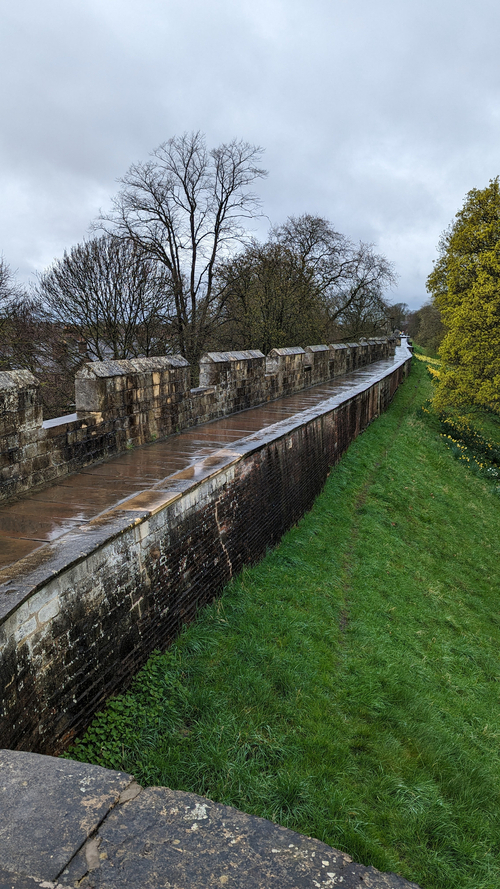
York is a good place to begin. If you go there by train, and cross the road after leaving the station, you immediately come to the city walls. They are built in stone, masses, and masses of it encircling the city. But where did the stone come from? - there's none in York or anywhere near it. Almost certainly it came from Tadcaster which is on that narrow band of magnesian limestone which goes north from Nottingham right through Yorkshire and eventually out to sea just north of Sunderland, and which is a valuable supplier of building stone.
Stone in York was not only used for the walls, but during Norman and medieval times in particular, for York Minster, for St Mary's Abbey, for the city's many churches, and for Clifford's Tower, all of it likely to have come from Tadcaster and almost certainly it came by water, down the Wharfe and up the Ouse. Tadcaster can only be reached by boat on a spring tide an event I've never seen. If you miss it, there are several weeks to wait before the next. Perhaps there were also convenient floods to transport the stone. York too used to be tidal, every day not just spring tides, and the building of Naburn Lock (sometime in the 1700s?) a few miles downstream made it reachable by boat all day every day. A good idea of what York the port looked like can still be had by looking downstream from Ouse Bridge in the middle of the city. Beverley Minster was also substantially built of Tadcaster stone (see information board outside the minster) and again one assumes it came by water, via Hull and a much longer journey from Tadcaster than to York. There is no doubt that for many centuries the navigable rivers were a major highway for the transportation of heavy materials. However, I know nothing about the boats that were used to carry the stone, or whether any have survived. For much of the way along the Ouse, and the Wharfe below Tadcaster there are now riverside footpaths.
There was also an important medieval quarry at Barnack near Stamford. From it came the stone for Ely Cathedral via the navigable waterways of the Fens, and I would guess the stone for Peterborough Cathedral and probably many of the Cambridge colleges. Barnack’s “Humps and Hollows,” the site of the medieval quarry, are well worth a visit, not least for the flora and fauna (late April/early May recommended), and the village church is also of interest.
Now let's flit across to Leeds. If you are arriving by bus, on leaving the bus station make for nearby Leeds Minster, and close to the back of it (the south side) is the River Aire and a convenient pedestrian bridge. Linger on it and enjoy the scene. You are now in the port of Leeds though it used to be very much busier than it is nowadays. It all began in 1700 when the Aire & Calder Navigation made the Aire navigable from Leeds (with a large cut at Woodlesford) to its junction with the Ouse at Airmyn from where there was a regular service along the coast to London. Prior to that the Aire was only navigable from Knottingley to Airmyn. In 1701 the River Calder became navigable from Wakefield. Heavy and bulky goods such as coal, limestone and wool were the major cargoes on the Aire and Calder. Further developments were the Selby Canal 1778 which provided a short cut to the Ouse and brought about the demise of Airmyn as a port (but still worth a visit for its splendid clock tower). The burgeoning of the canal age continued with the Barnsley Canal in c.1792. Its first two miles are now filled in, but near its junction with the Calder in Wakefield there used to be a pub called “The Jolly Sailor.” The Barnsley Canal brought coal from Silkstone which is well worth a visit for a reminder of the dreadful days of child labour with sad memorials to children working in a local drift mine and in 1838 drowned by a flash flood. The Rochdale Canal was completed in 1806, the Huddersfield Narrow with its over 3-mile long Standedge Tunnel in 1811, and the Leeds and Liverpool in 1816. Around 1819, the Aire & Calder Navigation was further improved with a canal from Knottingley to Goole which became a major inland port. A pleasant short urban walk in Leeds is to continue across the pedestrian bridge to the other side, then turn left and along the riverside path to the Armouries Museum. Retrace steps to the pedestrian bridge then continue along Dock Street and the former warehouses of the port of Leeds-to-Leeds Bridge at the bottom of Briggate. Close to the other side of the bridge is the junction of the Aire with the Leeds and Liverpool Canal.
To go back to the initial theme of this article, the Chesterfield Canal (completed in 1777) passes through a few miles of South Yorkshire near Anston, also on the magnesian limestone belt. This is where some of the stone for the House of Commons was quarried, and in 1840 was carried along the Chesterfield Canal to the River Trent and then by coastal shipping to London. Throughout the 1800s, even when there was a fully developed railway network, a massive amount of bulk cargo went by coastal shipping. There were many shipwrecks despite the large number of lighthouses and Trinity House pilots (but thanks to the magnificent voluntary work of the RNLI many people were rescued). In the churchyard of Bridlington Priory. there is a memorial to those who died at sea in the Great Gale of Bridlington of 1871 when several ships were wrecked. Walk down to the seafront and the charming maritime museum where there are maps recording the many shipwrecks on the nearby coast. And from outside of the museum enjoy the fine views of Flamborough Head.
Keith Wadd